On MONDAY (TODAY!) 4/8/2024, parts of NORTH AMERICA will be treated to a rare SOLAR ECLIPSE. The moon will pass over and obscure the sun, bringing upon darkness during the day depending upon your time zone.
Some New York and U.S.A, schools will dismiss early or school is cancelled in some markets. Bring your pets indoors during the eclipse. Wear special UV sunglasses while viewing the eclipse.
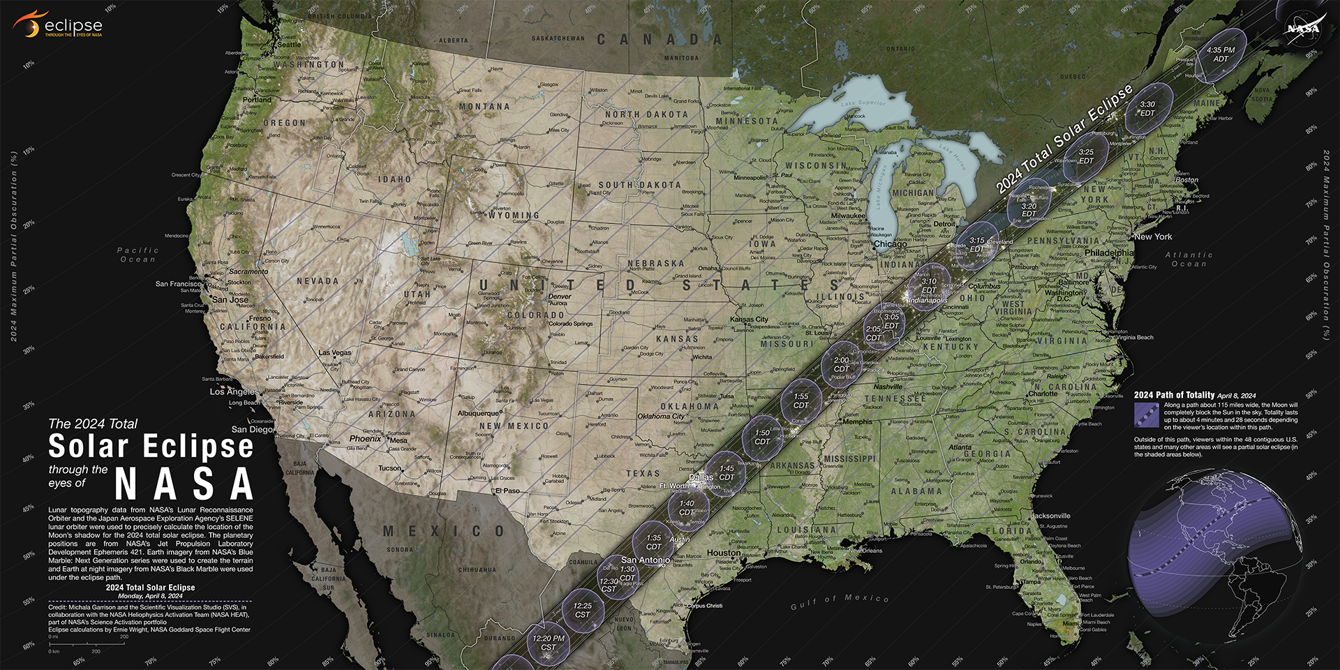
Are you on the "Path of Totality" for the solar eclipse? Enjoy! . . . .
FROM NASA:
The Monday, April 8, 2024, total solar eclipse will cross North America, passing over Mexico, the United States, and Canada. The total solar eclipse will begin over the South Pacific Ocean. Weather permitting, the first location in continental North America that will experience totality is Mexico’s Pacific coast at around 11:07 a.m. PDT.
Want to download this map and view other versions? Visit NASA’s Scientific Visualization Studio.
The path of the eclipse continues from Mexico, entering the United States in Texas, and traveling through Oklahoma, Arkansas, Missouri, Illinois, Kentucky, Indiana, Ohio, Pennsylvania, New York, Vermont, New Hampshire, and Maine. Small parts of Tennessee and Michigan will also experience the total solar eclipse. The eclipse will enter Canada in Southern Ontario, and continue through Quebec, New Brunswick, Prince Edward Island, and Cape Breton. The eclipse will exit continental North America on the Atlantic coast of Newfoundland, Canada, at 5:16 p.m. NDT.
This table provides the time that totality begins in some U.S. cities in the path of totality. These areas will also experience a partial eclipse before and after these times.
Location | Partial Begins | Totality Begins | Maximum | Totality Ends | Partial Ends |
|---|---|---|---|---|---|
Dallas, Texas | 12:23 p.m. CDT | 1:40 p.m. CDT | 1:42 p.m. CDT | 1:44 p.m. CDT | 3:02 p.m. CDT |
Idabel, Oklahoma | 12:28 p.m. CDT | 1:45 p.m. CDT | 1:47 p.m. CDT | 1:49 p.m. CDT | 3:06 p.m. CDT |
Little Rock, Arkansas | 12:33 p.m. CDT | 1:51 p.m. CDT | 1:52 p.m. CDT | 1:54 p.m. CDT | 3:11 p.m. CDT |
Poplar Bluff, Missouri | 12:39 p.m. CDT | 1:56 p.m. CDT | 1:56 p.m. CDT | 2:00 p.m. CDT | 3:15 p.m. CDT |
Paducah, Kentucky | 12:42 p.m. CDT | 2:00 p.m. CDT | 2:01 p.m. CDT | 2:02 p.m. CDT | 3:18 p.m. CDT |
Carbondale, Illinois | 12:42 p.m. CDT | 1:59 p.m. CDT | 2:01 p.m. CDT | 2:03 p.m. CDT | 3:18 p.m. CDT |
Evansville, Indiana | 12:45 p.m. CDT | 2:02 p.m. CDT | 2:04 p.m. CDT | 2:05 p.m. CDT | 3:20 p.m. CDT |
Cleveland, Ohio | 1:59 p.m. EDT | 3:13 p.m. EDT | 3:15 p.m. EDT | 3:17 p.m. EDT | 4:29 p.m. EDT |
Erie, Pennsylvania | 2:02 p.m. EDT | 3:16 p.m. EDT | 3:18 p.m. EDT | 3:20 p.m. EDT | 4:30 p.m. EDT |
Buffalo, New York | 2:04 p.m. EDT | 3:18 p.m. EDT | 3:20 p.m. EDT | 3:22 p.m. EDT | 4:32 p.m. EDT |
Burlington, Vermont | 2:14 p.m. EDT | 3:26 p.m. EDT | 3:27 p.m. EDT | 3:29 p.m. EDT | 4:37 p.m. EDT |
Lancaster, New Hampshire | 2:16 p.m. EDT | 3:27 p.m. EDT | 3:29 p.m. EDT | 3:30 p.m. EDT | 4:38 p.m. EDT |
Caribou, Maine | 2:22 p.m. EDT | 3:32 p.m. EDT | 3:33 p.m. EDT | 3:34 p.m. EDT | 4:40 p.m. EDT |


![[Valid RSS]](http://www.blogger.com/valid-rss-rogers.png "Validate my RSS feed")